Kōtō, Tokyo
| Kōtō 江東 |
|||
|---|---|---|---|
| — Special ward — | |||
| 江東区 · Kōtō City | |||
 |
|||
|
|||
 |
|||
 Kōtō
|
|||
| Coordinates: | |||
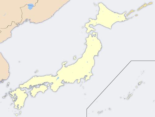
| Country | Japan | ||
| Region | Kantō | ||
| Prefecture | Tokyo | ||
| Area | |||
| - Total | 39.48 km2 (15.2 sq mi) | ||
| Population (2008) | |||
| - Total | 442,271 | ||
| - Density | 11,070/km2 (28,671.2/sq mi) | ||
| Time zone | Japan Standard Time (UTC+9) | ||
| Website | Kōtō | ||

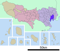
Kōtō (江東区 Kōtō-ku) is one of the 23 special wards of Tokyo, Japan. As of 2008, the ward has an estimated population of 442,271 and a density of 11,070 persons per km². The total area is 39.48 km². The ward refers to itself as Kōtō City in English.
Kōtō is located east of the Tokyo metropolitan center, bounded by the Sumidagawa to the west and the Arakawa to the east. Its major districts include Kameido, Kiba, Kiyosumi, Monzen-nakachō, Shirakawa, and Toyosu. The newly developed waterfront area of Ariake is in Kōtō, as is part of Odaiba.
Contents |
Geography
Kōtō occupies a position on the waterfront of Tokyo Bay sandwiched between the wards of Chūō and Edogawa. Its inland boundary is with Sumida. Much of the land is reclaimed, so there are few old temples or shrines.
Noteworthy places in Kōtō include
- In the former ward of Fukagawa: Kiba, Fukagawa, Edagawa
- In the former ward of Jōtō: Kameido, Ōjima, Sunamachi
- On recently reclaimed land: Ariake, Yumenoshima, Tokyo Rinkai Fukutoshin
History
The western part of the ward was formerly part of Fukagawa Ward of Tokyo City. It suffered severe damage in the Great Kantō Earthquake and was heavily bombed during World War II.
The special ward was founded on March 15, 1947 by the merger of the wards of Fukagawa and Jōtō.
Transportation
Rail
- JR East
- Chūō-Sōbu Line: Kameido Station
- Keiyō Line: Etchūjima Station, Shiomi Station, Shin-kiba Station
- JR Freight
- Etchūjima Branch Line: Etchūjima Kamotsu Station
- Tokyo Metro
- Tōzai Line: Monzen-nakachō Station, Kiba Station, Tōyōchō Station, Minami-sunamachi Station
- Yūrakuchō Line: Toyosu Station, Tatsumi Station, Shin-kiba Station
- Hanzōmon Line: Sumiyoshi Station, Kiyosumi-shirakawa Station
- Tokyo Metropolitan Bureau of Transportation
- Toei Shinjuku Line: Morishita Station, Sumiyoshi Station, Nishi-Ōjima Station, Ōjima Station, Higashi-Ōjima Station
- Toei Ōedo Line: Morishita Station, Kiyosumi-shirakawa Station, Monzen-nakachō Station
- Tobu Railway
- Kameido Line: Kameido Station, Kameido-suijin Station
- Tokyo Waterfront Area Rapid Transit
- Rinkai Line: Shin-kiba Station, Shinonome Station, Kokusai-tenjijō Station, Tokyo Teleport Station
- Yurikamome
- Yurikamome: Fune-no-kagakukan Station, Telecom Center Station, Aomi Station, Kokusai-tenjijo-seimon Station, Ariake Station, Ariake-tennis-no-mori Station, Shijō-mae Station, Shin-toyosu Station, Toyosu Station
Highway
- Shuto Expressway
- C2 Central Loop (Itabashi JCT - Kasai JCT)
- No.7 Komatsugawa Route (Ryogoku JCT - Yagochi)
- No.9 Fukagawa Route (Hakozaki JCT - Tatsumi JCT)
- B Bayshore Route (Kawasaki-ukishima JCT - Koya)
Air
- Tokyo Heliport is in Shin-Kiba.
Economy
Ibex Airlines is headquartered in the ward.[1] Sony operates the Ariake Business Center in Kōtō.[2]
Seta Corporation was headquartered in Kōtō.[3]
Famous places
- ageHa nightclub
- Kameido Tenjin Shinto Shrine
- Tomioka Hachiman Shrine
- Fukagawa Fudo-son
- Kiyosumi Garden
- Museum of Contemporary Art Tokyo
- Tokyo Big Sight (Tokyo International Exhibition Center)
- Ariake Coliseum, site of Japan Open Tennis Championships, All Japan Tennis Championships and so on
- Ariake Tennis Forest Park, which has Ariake Coliseum and 48 tennis courts
- Suzaki Baseball Field, site of Japanese Baseball League games in 1930s
- Kiba Metropolitan Park
- Yumenoshima Tropical Greenhouse Dome
- Shin-Kiba 1st Ring
Education
Colleges and universities
- Ariake Junior College of Education and the Arts (Ariake Kyōiku Geijutsu Tanki Dbigaku)
- Tokyo University of Marine Science and Technology (Tokyo Kaiyo Daigaku, part of the national university system)
Primary and secondary schools
Public elementary and middle schools are operated by the Koto City Board of Education. Public high schools are operated by the Tokyo Metropolitan Government Board of Education.
- Daisan Commercial High School [1]
- Fukagawa High School [2]
- Higashi High School [3]
- High School of Science and Technology [4]
- Johtoh High School [5]
- Koto Commercial High School [6]
- Oedo High School [7]
- Sumida Technical High School [8]
International schools
International schools are independently owned and operated.
- K. International School Tokyo [9]
Sister cities
As of April 20, 1989, Kōtō became the Sister City of Surrey, British Columbia, Canada.
See also
References
- ↑ "Corporate Profile." Ibex Airlines. Retrieved on May 20, 2009.
- ↑ "Access & Map." Sony. Retrieved on January 19, 2009.
- ↑ "Corporation Data." Seta Corporation. February 6, 2007. Retrieved on April 24, 2009.
External links
- Kōtō official website in English
|
|||||||||||||||||
|
|||||||||||||||||||